New Journal Paper Out!
Our paper entitled “Productive Crop Field Detection: A New Dataset and Deep-Learning Benchmark Results” was just published in the IEEE Geoscience and Remote Sensing Letters.
Food production needs to grow by 70% to meet the demands of the expected world population by 2050 (Nelson et al., 2010). Motivated by this challenge, agriculture has adopted technologies to improve and optimize input returns while preserving natural resources. Integrating these technologies promotes a farming management concept known as precision agriculture (Zhang et al., 2002).
To efficiently organize and manage large crops, farmers leverage remote sensing to divide their land into smaller observation units that this work will refer to as agricultural or crop fields. A field shape is designed based on topography and mechanization planning. A productive crop field is an area consistently used for the cycle of growth and harvest of a crop, typically yearly but more often in some regions with favorable soil and weather.
Thanks to the availability of a massive amount of labeled data, the development of artificial intelligence (AI), particularly machine learning (ML) and deep learning (DL), has allowed for acceleration and improvement in many areas of agriculture (Garcia-Pedrero et al., 2019; Persello et al., 2019; Masoud et al., 2020; Waldner and Diakogiannis, 2020; Waldner et al., 2021). Despite all the advances, having an adequate amount of labeled data to train such methods can be costly and not always affordable for precision farming.
Usually, farmers rely on experts to build the field boundaries in dedicated Geographic Information Systems (GIS) software. Despite the expert’s ability and knowledge, finding crop fields and drawing their boundaries has been a major, expensive, and time-consuming challenge (Waldner and Diakogiannis, 2020). The larger the customer’s land is, the more significant the number of fields to be created. Finding productive fields is even more challenging because it requires previous knowledge of these areas or the analysis of satellite images over time.
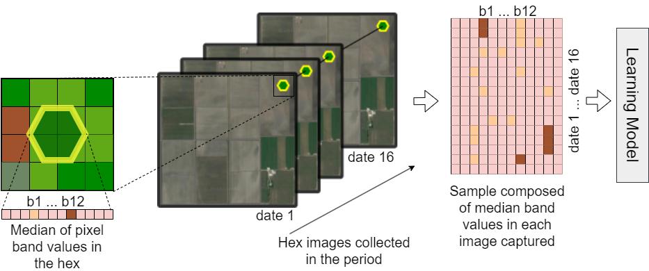
Aiming to facilitate access to data ready to support ML and DL models for productive crop field detection, we introduce a new dataset of productive fields based on agriculture machine’s operation combined with Sentinel-2 images collected over a period of time. Firstly, this information is aggregated in geospatial L12 hexagons, establishing a common ground for employing different satellite sources with different resolutions. Secondly, typical farmers are usually interested in monitoring productive areas rather than all possible fields since many are not fertile or suitable for any crop. For this purpose, the proposed dataset contains highly accurate positive samples (i.e., productive crop fields) and inferred negative ones, making it well-suited for positive and unlabeled learning (Denis et al., 2005). Moreover, recent advances suggest that self-supervised methods (e.g., contrastive learning) may also provide a promising alternative even for cases where labeled samples are scarce (Güldenring and Nalpantidis, 2021). Finally, we offer state-of-the-art ML and DL benchmark results for further comparison, including classification methods with different training strategies (i.e., supervised learning, self-supervised learning, and semi-supervised classification of unlabeled data).
Are you looking for a robust dataset for training highly accurate prediction models to automatically detect productive crop fields? Check our paper!
Jurandy Almeida
Professor of Computer Science
My research interests are mainly in the areas of computer vision, deep learning, image processing, information retrieval, machine learning, and pattern recognition.